
Photographers take images of Qomolangma from similar angles that mountaineers took a century ago to highlight the changing landscape, Yang Feiyue reports.
 Photographers Ma Chunlin and Dong Shuchang capture the majesty of Qomolangma from a similar angle of photographs taken by English mountaineer George Mallory a century ago. (PHOTO PROVIDED TO CHINA DAILY)
Ma Chunlin was beyond thrilled when he finally got the chance to take photos of Qomolangma, also known as Mount Everest, from various angles. In late November, the 26-year-old, originally from Hohhot, North China's Inner Mongolia autonomous region, named a peak "Lholin" during his trek. The area was also explored by English mountaineer George Mallory, who was part of an expedition to Qomolangma in 1921.
"Lho means 'south' in Tibetan, while lin means an 'enclosed place', and the whole name might be interpreted as a good place surrounded by glaciers in the south, which fits perfectly with the geological environment of 'Lholin'," Ma explains.
It didn't cross his mind that local guides would have readily taken on the nomenclature, which was soon used on the map by himalaya-info.org, one of the world's biggest platforms with information on the geography, topography and history of the Himalayas. Ma's mission shed some light on the changes in the Himalayas over the past 100 years.
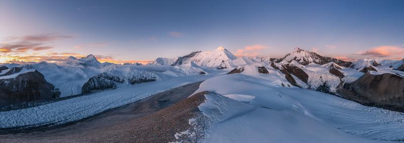
In photos by Ma and his journey partner Dong Shuchang, one can clearly see, before the Kharta Glacier, a large lake, which could barely be seen in the photo taken from a similar angle by Mallory.
"We hope it can make more people aware of the speed of glacier melting in a very direct way," Ma says.
He conservatively estimates the lake area to be around 900,000 square meters. He's been fascinated by the geological wonder since his college time in Tianjin and started to work as a part-time Himalayan tour guide during his summer vacations.
"I figured I could see the mountain myself this way," Ma says. "I was out of words when I first saw Qomolangma in 2015."
However, he was caught off guard when his guests began to ask him about many other peaks in the neighborhood. It spurred him to make "inroads into the complex mountain range".
Ma says he used an e-map, compared and found corresponding parts on the map.
The more he learned, the more he was fascinated, and the better he could do as a tour guide.
"The Himalayas are in different sections made by valleys and rivers, and each section has its own story," Ma says. "There are different lifestyles among each of those sections, some running from east to west and some from south to north."
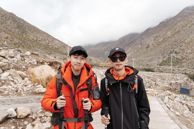 Ma Chunlin (right) and Dong Shuchang pose for a photo during their trek to Qomolangma. (PHOTO PROVIDED TO CHINA DAILY)
Ma continued the tour guide business after he graduated in 2018, took on commercial photography and started writing about the Himalayas for various publications on the side, such as the Chinese National Geography.
"I followed the satellite cloud image, and took my guests to places where the weather would be the best," Ma says, adding that the goal was to seek the best possible view of the Himalayas.
"Our side offers a superb view of the Himalayas, and the Tibet section of National Highway 219 makes things easier for sightseeing (of the mountain)."
He would also take his guests to some lesser-known corners in the mountain range.
"Lholin" sits in the Kharta Valley area which lies to the east of Qomolangma. Ma had wanted to explore the valley after his research. The valley is 5,700 meters above sea level and is in a different direction from the well-known Qomolangma Base Camp. The route to the valley can barely be spotted on the map. It offers a great angle to view Qomolangma.
In 1921, Mallory found a climbing route to Qomolangma from the north side in Kharta Valley and accurately developed the map of the Qomolangma area from the valley. In 1922, Mallory launched a second expedition to make the first ascent of the world's highest mountain. During an expedition in 1924, Mallory and his climbing partner, Andrew Irvine, disappeared on the northeast ridge of Qomolangma. Mallory's remains were discovered in 1999. Whether Mallory and Irvine reached the summit before they died has been a subject of debate over the years.
Ma was fascinated by the history and the fact that the valley has remained off the beaten tracks ever since.
"One can see a spectacular pyramid shape of Qomolangma in the Kharta Valley area, but the journey to the valley is long and doesn't offer much of a sight," Ma says. "I couldn't help but wonder what is in Kharta Valley, and what has changed there over the past century," he says.
"It's an unknown path. A partner can make things easier and safer," Ma says.
He embarked on a trek with his journey partner Dong, who is from Northwest China's Ningxia Hui autonomous region, in September. Dong won the 2021 Astronomy Photographer of the Year competition with his solar-eclipse photography work of 2020, titled Golden Ring.
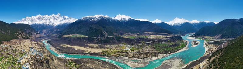 A view of the Yarlung Zangbo Grand Canyon in Nyingchi, the Tibet autonomous region. (MA CHUNLIN / CHINA DAILY)
They studied hundreds of pages of expedition logs left by Mallory and his team and figured out the route to Kharta Valley and the time it would take to cover it. Dong had focused much of his attention on astronomical photography earlier and learned to hike in the wilderness and studied the Himalayas' history and formations of glaciers and climate in the mountainous areas for the trek. Yet, the harsh conditions caught them off guard.
"We didn't have high-altitude camping and hiking experience, so we made many silly mistakes. For example, we even forgot to buy chocolate bars that could conveniently 'recharge our batteries'," Ma says.
They had altitude sickness while enduring rain, snow, hail and gale.
"I was sick to the bursting point during the last night at the valley," Ma recalls.
But, thrills pulled them through from experiencing the biodiversity, including lush forests, tropical and meadow plants, snowy peaks, glaciers and lakes. The most thrilling moments came during sunrise, which gave them two hours of photography time. They attached the camera to a drone until the battery ran out.
"We finished almost all the things we had planned," Ma says.
Nature also threw in a gift for them. There were two clouds over Qomolangma, resembling a hat over the peak. Dong was mesmerized by the sunrise scene.
"The stunning views of the giant mountain peaks turned pink by the sunrise made me forget my altitude sickness," Dong says. "I will surely go back."
Although Ma has seen plateau scenery before, he was still amazed by it.
"It felt like a shock to my core, to the point of kneeling down," Ma says.
They wanted to stay a bit longer, but wild yaks that carried their baggage didn't have any grass to eat in the valley, so they had to return immediately after the sunrise shoot.
Ma is furthering his studies in local languages, plants, rocks and climates of the Himalayas.
"During the years of exploration in the mountains, I have constantly verified the names of these great mountains with local people, and then combined various materials to build connections among their relationship," Ma says.
"This process is like looking for treasures, which is interesting and endless. Modern technology also allows us to acquire images of these mountains in ultra-high definition resolution."
Ma says he is hoping to enable better public understanding of the Himalayas and call more attention to the protection of the environment, rather than creating another travel hot spot, by publicizing his journey.
Contact the writer at yangfeiyue@chinadaily.com.cn