
Hong Kong’s weather forecaster will consider issuing typhoon signal No. 3 directly, skipping the precautionary alert No. 1 on Monday as Tropical Cyclone Fengshen moves closer to the city.
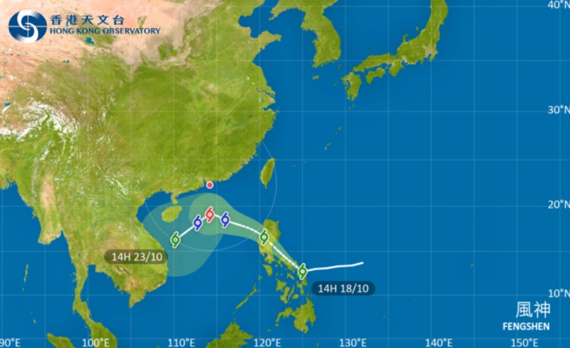
At 4 pm on Saturday, Fengshen was centered about 450 kilometers east-southeast of Manila and is forecast to enter within 800 km of Hong Kong later on Sunday, moving at about 22 km per hour, according to the Hong Kong Observatory.
“Depending on the intensity of Fengshen, the distance of the gale winds from Hong Kong and the change in local wind conditions, the observatory will assess the need for issuing higher tropical cyclone warning signals by then,” the HKO said in a 4:20 pm bulletin on Saturday.
According to the present forecast, Fengshen will be closest to Hong Kong on Tuesday.
Temperatures over most parts of Hong Kong rose to about 33 degrees Celsius on Saturday afternoon.
MORE TYPHOON STORIES:
- Hong Kong in recovery mode after Ragasa onslaught
- HK ‘narrowly avoids’ worst of Super Typhoon Ragasa, expert says
- Flood warning as Hong Kong braces for storm Wipha
With pressure rising over the northern part of southern China, an intense northeast monsoon is expected to reach the coast of Guangdong on Sunday, and local winds will strengthen gradually, said the observatory.
“Under the combined effect of Fengshen and the monsoon, it will be persistently windy and will become cloudy with rain early to midweek next week.”
Fengshen will also start to turn southwestwards gradually under the influence of the monsoon, but there are uncertainties in the location of the turn, the HKO added.
Cautioning that seas will be rough with swells, the observatory said flooding may occur over some low-lying coastal areas during the high tides for a few consecutive nights next week.