
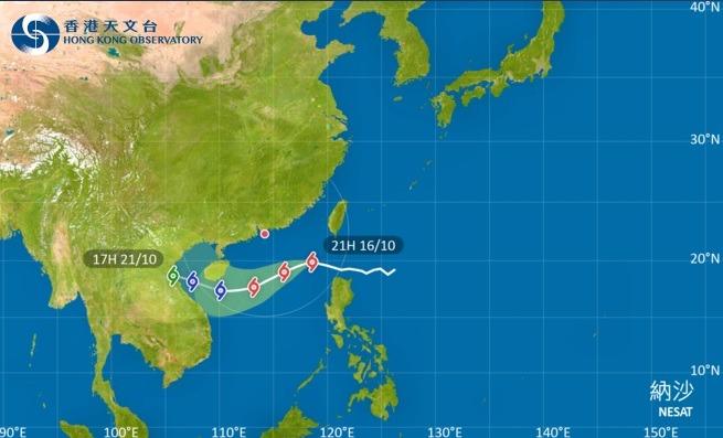
 This screengrab from the official website of the Hong Kong Observatory shows the forecast track of Typhoon Nesat.
HONG KONG – The Hong Kong Observatory raised Typhoon Signal No 1 at 9:20 pm on Sunday as Typhoon Nesat moved closer to the city.
The Standby Signal No 1 will remain in force before 5 am tomorrow morning. Winds are expected to strengthen gradually tomorrow. Depending on the changes in local winds, the Observatory will consider issuing the Strong Wind Signal No 3.
The Hong Kong Observatory
In a weather advisory, the HKO said Nesat will gradually edge closer to the coast of southern China from Sunday night to Monday morning.
ALSO READ: HKO: Hong Kong's September dry and exceptionally hot
At 9 pm, Typhoon Nesat was estimated to be about 530 kilometres east-southeast of Hong Kong and is forecast to move west or west-southwest at about 15 kilometers per hour crossing the northern part of the South China Sea.
"The Standby Signal No 1 will remain in force before 5 am tomorrow morning. Winds are expected to strengthen gradually tomorrow. Depending on the changes in local winds, the Observatory will consider issuing the Strong Wind Signal No 3," said the HKO.
Under the combined effect of Nesat and the northeast monsoon, there will be occasionally strong winds over offshore waters and on high ground. the HKO noted.
READ MORE: HKO warns of prolonged heat, mercury could hit 35 C
"Members of the public are advised to take note of the latest weather information before departing tomorrow morning," said the Observatory.