
Three mighty waterways provide the lifeblood for a natural wonder, report Yang Yang in Beijing and Li Yingqing in Kunming.
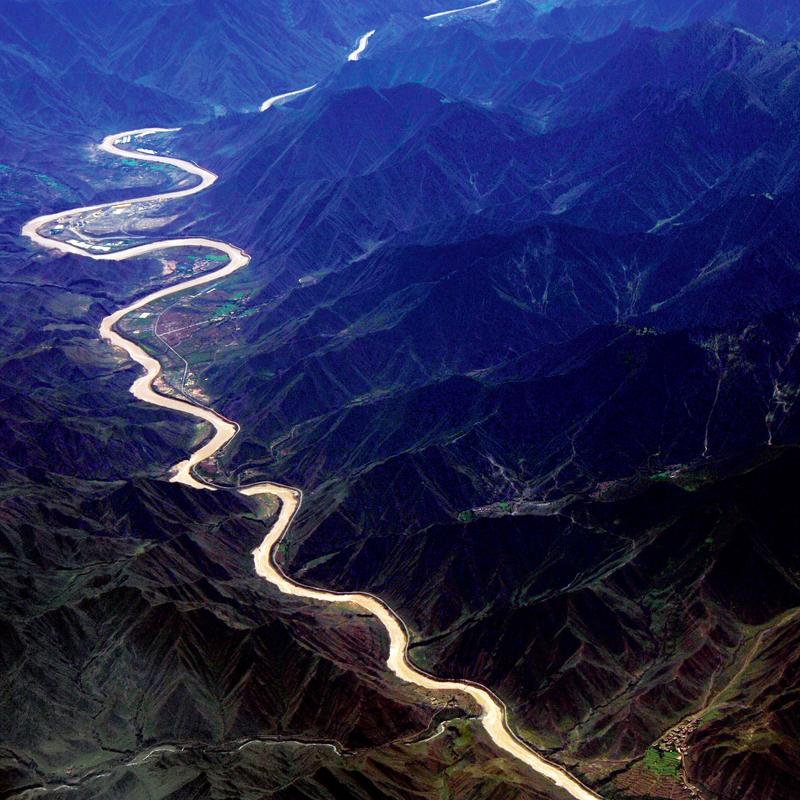 The Lancang River flows through mountainous areas in Yunnan province. (PHOTO PROVIDED TO CHINA DAILY)
Editor's note: China is home to 56 UNESCO World Heritage sites. To find out how these natural and cultural gems still shine and continue to inspire the nation in this new era of development, China Daily is running a series of reports covering 10 groups of selected sites from across the country. In this installment, we explore an oasis of biodiversity nestled amid the mountains of Yunnan province.
It is a story transcending time, a witness of sea changes, a land with "mystery rivers", an ark of life, a symphony of natural wonders, a museum sheltering the eternal and the transitional, a piece of evidence showing that life can be both tough and frail, and a history that records people's changing perceptions of nature.
It is the Three Parallel Rivers of Yunnan Protected Areas in the northwest part of Yunnan province, which is located in Southwest China.
The story began about 40 million years ago, when the Indian Plate collided with the Eurasian Plate, raising the Qinghai-Tibet Plateau and creating the rumpled peaks of the Hengduan Mountains.
The roof of the world, the Qinghai-Tibet Plateau, cradles the sources of the longest rivers in Asia. In between the precipitous north-south ranges of the rippling Hengduan Mountains runs a mighty trio of waterways-the Nujiang in the west, the Lancang in the middle and the Jinsha in the east.
Respectively they are the upper streams of the Salween River, which runs through Myanmar, the vast Mekong River and the Yangtze River, the world's third-longest watercourse.
One singular thing about the three rivers is that they run abreast for 170 kilometers through Yunnan, before the Jinsha River turns drastically northeastward and finally meets the East China Sea.
Another is that they run unusually close to each other. The shortest distance between Lancang and Jinsha measures 66 km, and between Lancang and Nujiang, the distance is less than 19 km.
That was how, in 1985, this geographical wonder, highlighted on a satellite map, drew the attention of an expert from UNESCO, which marked the commencement of a long journey to apply for inclusion on the World Heritage List.
UNESCO selects world heritage sites according to four criteria: aesthetic importance, outstanding examples representing major stages of Earth's history, exceptional examples of significant ongoing ecological and biological processes, and the most significant natural habitats for in situ conservation of biological diversity. Meeting one of them is usually adequate.
The Three Parallel Rivers of Yunnan Protected Areas went on the list in 2003. Liang Yongning, a professor of geology from Kunming University of Science and Technology in Yunnan, says it is the only world heritage site in China that meets all four criteria.
Covering 1.7 million hectares, the site consists of 15 different protected areas that have been divided into eight clusters, each providing a representative sample of the full range of the biological and geological diversity of the Hengduan Mountains, Shangri-La included.
Back in the autumn of 2002, Liang, an expert on the team preparing the area's application for inclusion on the list, received two experts from UNESCO who were sent to investigate the region.
Two decades ago, the area was one of the most impoverished in China. It was blocked by unscalable mountains and rushing rivers. Roads were carved into escarpments and some bridges were merely cables which people used to get across roaring torrents together with their animals.
"We thought it would take one month to complete the expedition because we needed to cross the three rivers, as well as the divides and watersheds in between, to see all of them. At that time there was no highway connecting the rivers," he says.
However, no matter how big the sites are, UNESCO allows, at most, two-week investigations.
With the help of local people, they planned an east-west route that started from the Jinsha River and ended west of the Gaoligong Mountains located on the west bank of the Nujiang River.
"We tried everything. If there was a highway, we took off-road vehicles. If there was no highway, we rode horses, and if even horses couldn't go on, we went on foot," he says.
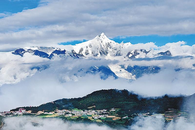 Snowcapped Kawagebo is the highest peak in the Three Parallel Rivers of Yunnan Protected Areas. (PHOTO PROVIDED TO CHINA DAILY)
It was a hard expedition. In the area, a world of sierras, stand 118 glaciated peaks of more than 5,000 meters above sea level. The highest is Kawagebo Peak (6,740 meters) in Dechen county of Dechen Tibet autonomous prefecture, in the Lancang River Grand Canyon. This protected area is inhabited by the endangered Yunnan snub-nosed monkeys.
Liang remembers how the weather kept changing when they climbed over the Biluo Snow Mountains located in the Lancang-Nujiang divide. Biluo's snowcapped range extends 142 km with 15 glaciated peaks measuring over 4,000 meters above sea level. The 4,500-meter-high Laowo Mountain stands out as the most beautiful. Elevation drops 3,200 meters before reaching the Lancang River.
"At some points, we very cautiously rode horses along narrow roads on the cliffs. Actually, when we prepared for the expedition, several people were injured while trying the dangerous roads," he says.
The expedition lasted 12 days. When the experts departed, one of them, Canadian Jim Thorsell, gifted Liang a book.
It was a copy of an excerpt from The Mystery Rivers of Tibet by British botanist and explorer Francis Kingdon-Ward, who traveled across the three parallel rivers and the watersheds in 1913 to collect plant species for British horticulture businesses and scientific research.
Liang found their route overlapped in many respects with the one Ward traveled nearly 90 years prior.
"Thorsell read the book and told me the natural conditions of the area had not changed much over the years," Liang says.
Ward devoted the whole fifth chapter to the sacred mountain of Kawagebo. It was also a waypoint on the UNESCO expedition.
Kawagebo and other glaciated peaks, such as Biluo, Baima and Haba snow mountains, represent the spectacular beauty of the site.
In addition to the magnificent skyline of the glaciers, the area is also granted with other outstanding scenic landforms, such as alpine karst, especially the Stone Moon above the Nujiang Grand Canyon, and the "tortoise shell" of the alpine Danxia, a landform characterized by its reddish sandstone features.
As elevation drops from over 6,740 meters to 760 meters, the area presents every kind of natural view in the Northern Hemisphere except those of oceans and deserts-glaciers, alpine valleys, alpine lakes, alpine meadows, broad-leaved and coniferous forests, and so on.
Having witnessed a literal sea change, the area is a museum of geology, housing a collection of diverse rock types, such as alpine sandstone landforms, granite monolith and a range of karst formations.
Despite bordering tropical Myanmar to the west, the area provides various climates for creatures living in subtropical, temperate and frigid zones, making it the region with the richest biodiversity in China.
Such unique geographical locations, and hydrogeological and weather conditions create diverse atmospheres, which are summarized by the local people as "the weather changes every five kilometers".
Being located at the juncture of East Asia, Southeast Asia and Qinghai-Tibet Plateau, the area not only provides a corridor for the migration of species, endemic or otherwise, but also preserves species that can rightly be called living fossils-for example, the Cyathea tree ferns which hark back to the time of the dinosaurs.
The area, described by locals as "tens of thousands of creatures living on one mountain", shelters more than 20 percent of higher plant species (of relatively complex or advanced characteristics) and 25 percent of animal species in all of China.
For example, the big tree rhododendron is native to the Gaoligong Mountains. Since 2015, people have sought to cultivate the critically endangered plant. The good news is that 60 percent of the 80 saplings planted in the wild in 2017 have survived. So have the 200 saplings planted in May last year.
Apart from fauna and flora, the area is also home to 16 ethnic groups, including Tibetan, Lisu, Bai, Pumi and Derung, who, regardless of having different languages, cultures and traditions, live harmoniously together.
Today, as more creatures perish at an ever-increasing speed around the world, in the inaccessible mountains of the Three Parallel Rivers of Yunnan Protected Areas, new species are discovered, almost every year. This, alone, makes it an authentic natural wonder.
Contact the writers at yangyangs@chinadaily.com.cn