
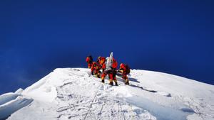
 A Chinese surveying team reaches the summit of Mount Qomolangma on May 27, 2020. (PHOTO / XINHUA)
The height of the world's tallest mountain, Mount Qomolangma, also known as Mount Everest in the West, has been updated by surveyors and it is now measured as standing 8848.86 meters above sea level, China and Nepal announced on Tuesday.
The measurement was jointly announced by President Xi Jinping and his Nepalese counterpart Bidya Devi Bhandari as they exchanged letters on Tuesday.
Tuesday's announcement on the mountain's height is significant in linking the past and the future, and it fully reflects the high level of the evolving China-Nepal relationship, President Xi Jinping said in a letter to his Nepalese counterpart Bidya Devi Bhandari
The two governments agreed last year to jointly announce the new height. In his letter, Xi noted that the teams of the two countries have overcome various difficulties, carried out important work and finally determined the new height.
ALSO READ: Surveyors take giant steps to recalculate height of Qomolangma
Mount Qomolangma is an important symbol of bilateral friendship, and the two countries have made the world's highest mountain a symbol of their border as well as China-Nepal friendship, Xi noted.
Tuesday's announcement on the mountain's height is significant in linking the past and the future, and it fully reflects the high level of the evolving China-Nepal relationship, Xi said, adding that China is willing to work with Nepal to promote cooperation in environmental protection and scientific research on Qomolangma.
The Nepalese president said in her letter that the mountain is a long-term symbol of Nepal-China traditional friendship, and she is pleased to join Xi in announcing the latest measurement, which is of historic significance.
Speaking on bilateral ties, Xi said that this year marks the 65th anniversary of the establishment of bilateral diplomatic relations. Joint efforts have seen stronger political mutual trust and advances in the construction of the Belt and Road, and the Trans-Himalayan Multi-Dimensional Connectivity Network is shifting from a vision to a reality.
China and Nepal should promote the growth of their strategic partnership, jointly build a closer community of shared future and further benefit the two peoples, Xi said.
The Nepalese president said Nepal and China have always been great neighbors, friends and partners, and cooperation between the two countries in areas such as economic development, connectivity and culture serves the interests of both sides.
Xi's state visit to Nepal last year brought bilateral relations and cooperation into a new era, and the two governments will be committed to implementing the consensus reached during the visit, she said.
A team of Chinese surveyors climbed the mountain in May this year. Earlier, Nepalese surveyors reached the top of the mountain in May 2019 to conduct measurements.
READ MORE: China expedition reaches world's highest summit, remeasures peak
The two sides reached a conclusion on the height of the mountain before Tuesday's announcement.
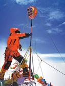 A Chinese surveyor conducts measurements on the summit of Mount Qomolangma on May 27, 2020. (TASHI TSERING / XINHUA)
Li Guopeng, captain of the Ministry of Natural Resources' First Geodetic Surveying Brigade, said the latest survey effectively combined traditional measuring techniques and cutting-edge technologies to ensure its accuracy and precision.
The survey this year involved the Beidou navigation satellites system for receiving signals and data, and it also included gravity surveys, Li said.
In 1975, Chinese surveyors measured Qomolangma as standing 8,848.13 meters above sea level. During that survey, the Chinese team erected, for the first time, a survey marker on top of the peak.
In 2005, another Chinese survey registered the summit's rock height at 8,844.43 meters.
Guo Chunxi, director of the Ministry of Natural Resources' Geodetic Data Processing Center, said a range of innovations were made during the data processing of the latest survey.
"This year's outcome exceeds the results of the summit survey in 2005 in reliability and precision," Guo said.
Contact the writers at zhangyunbi@chinadaily.com.cn