

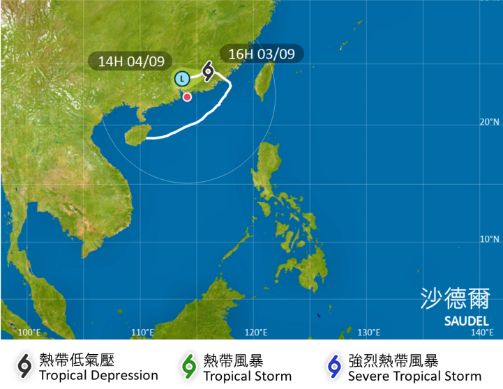
Tropical Cyclone Saudel is expected to weaken quickly and the chance of hosting the No 3 typhoon warning signal on Friday is relatively low, according to Hong Kong’s weather forecaster.
In a weather bulletin, the Hong Kong Observatory said on Thursday afternoon that Saudel will move across the inland areas of eastern Guangdong on Thursday night and Friday morning, edging closer to the vicinity of the Pearl River Estuary.
ALSO READ: HK to keep T1 as Saudel expected to edge back toward city
“However, it is expected to weaken relatively quickly. The chance of strong winds prevailing generally over Hong Kong is not high,” reads the bulletin. “The chance of issuing the Strong Wind Signal, No 3 is rather low.”
The lowest-tier Standby Signal, No 1, which has been in force over the city since early Monday evening, will be canceled once the tropical cyclone weakens into an area of low pressure, the observatory added.
As of 4 pm Thursday, Saudel was estimated to be about 300 kilometers northeast of Hong Kong and is forecast to move west-southwest at about 12 kph across the inland areas of eastern Guangdong and continue to weaken.
READ MORE: HK experts urge swift action as El Nino threatens to bring more heat, typhoons
The observatory said local winds will be occasionally strong offshore and on high ground on Thursday night and early on Friday due to the combined effect of Saudel and the northeast monsoon.
It added that there will still be swells on Friday and those planning to visit Guangdong, Macao, the outlying islands or remote parts of Hong Kong should note that changes in weather may affect their trips.
Hong Kong is expected to have mainly cloudy weather with one or two showers and bright periods on Friday, the HKO added.
