

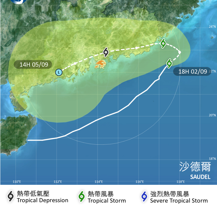
The No 1 typhoon warning signal will remain in force until Thursday morning, with Hong Kong’s weather forecaster cautioning that Tropical Cyclone Saudel was again expected to edge closer to the city on Friday.
Saudel took a northeastward track on Wednesday and its distance from Hong Kong increased gradually, but it was forecast to change direction on Thursday and again move closer toward the territory the following day, the Hong Kong Observatory said in a weather bulletin on Wednesday afternoon.
“Saudel is expected to linger over the northeastern part of the South China Sea and maintain a distance of about 300 kilometers or more from Hong Kong tonight and tomorrow morning,” the HKO said. “The Standby Signal, No 1 is expected to remain in force for the rest of today to tomorrow morning.”
ALSO READ: HK experts urge swift action as El Nino threatens to bring more heat, typhoons
The Standby Signal, No 1 – the city lowest-tier typhoon signal – means that a tropical cyclone is centered within 800 km of Hong Kong.
As of 5 pm Wednesday, Saudel was estimated to be about 330 km east of Hong Kong and was forecast to move northeast at about 10 kph.
By Thursday, the tropical cyclone is forecast to gradually turn westwards, skirting the coast of eastern Guangdong, the HKO said.
READ MORE: HKO: 4 to 7 typhoons may hit Hong Kong this year
Saudel will then again edge closer to the vicinity of the Pearl River Estuary on Friday, the observatory said, adding that there are “large uncertainties” about its intensity by then.
The HKO said it will closely monitor the Saudel’s movement and assess the need of issuing the Strong Wind Signal, No 3 when it edges closer to the estuary.
Hong Kong is expected to have mainly cloudy weather on Thursday, with one or two showers and sunny intervals, and a maximum temperature of around 31 degrees Celsius, the HKO added.
