
The Hong Kong Observatory said it will raise the typhoon warning signal No. 3 on Monday afternoon as Tropical Cyclone Fengshen moved across the northern part of the South China Sea, edging closer to the city.
The HKO said it will raise the will issue the Strong Wind Signal, No 3 directly at 5:20 pm to replace the Strong Monsoon Signal as the typhoon was expected to bring rainy and windy weather in the next couple of days.
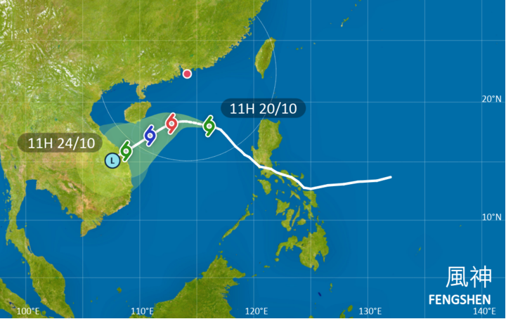
But under the influence of the monsoon, Fengshen will start to turn southwestwards and weaken on Tuesday, the observatory added.
“Under the combined effect of the intense northeast monsoon and Tropical Cyclone Fengshen, it will be persistently windy and appreciably cooler with rain over the coast of southern China in the next couple of days. Seas will be rough with swells,” the HKO said.
The observatory said temperatures will drop to around 19 degrees Celsius in urban areas, and a couple of degrees lower in the New Territories.
At noon on Monday, Fengshen was centered about 300 kilometers south-southwest of Dongsha, with maximum sustained wind speeds of 85 kilometers per hour near its center.
The tropical cyclone was forecast to move west-northwest at about 18 kph across the northern part of the South China Sea, edging closer to the coast of Guangdong gradually.
ALSO READ: Observatory: HK’s August much wetter than usual
The observatory also said that, under the combined effect of spring tide, the northeast monsoon and Fengshen, flooding may occur over some low-lying coastal areas during high tide for a few consecutive nights this week.
The water level over Victoria Harbour will rise to around 3 meters above the Chart Datum at night from Tuesday to Thursday, the HKO added.