
 Police officers evacuate children stranded in floodwaters in Hefei, Anhui province, on July 20, 2020. The city has adopted traffic restrictions for some flood-affected roads and mobilized officers to help with flood relief efforts. (ZHANG HONGFEI / FOR CHINA DAILY)
The risk of major flooding looms increasingly large along the Huaihe River, part of the dividing line between China's northern and southern regions. The rain-swollen river has risen above alert-triggering levels, with more torrential rain forecast for the river's basin.
Due to incessant downpours, the water level at the Wangjiaba hydrological station reached 27.5 meters, its warning level, late Friday, marking the river's first flood of the year.
However, the water level further increased to 29.66 meters at 6:36 am Monday morning, 0.36 meters above the maximum design level for dikes in the section, according to the Huaihe River Commission.
On Monday morning, the Huaihe River Commission issued a red alert for flooding, the highest in a four-tier color-coded warning system, while upgrading the emergency response to Level I, its highest, amid a "grim flood control situation"
"The water is expected to keep swelling," the commission said in a news release on Monday.
ALSO READ: China braces for more floods, extremely heavy downpours
One of the country's seven major waterways, the Huaihe drops 178 meters over 360 kilometers in its upper reaches. In its middle reach of 490 km, mostly in Anhui province, however, the drop is just 16 meters, making it difficult for floods to recede in the province. It also passes through Henan, Jiangsu and Shandong provinces.
On Monday morning, the commission issued a red alert for flooding, the highest in a four-tier color-coded warning system, while upgrading the emergency response to Level I, its highest, amid a "grim flood control situation".
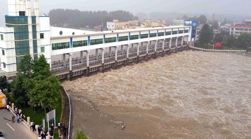
At 8:30 am Monday, the Wangjiaba Dam opened all of its 13 sluice gates to discharge floodwaters to the Mengwa Flood Diversion Area in an effort to relieve the pressure downstream.
The diversion area, a 180-square-kilometer basin, can hold nearly 750 million cubic meters of water.
The area, located in Fuyang, Anhui, is home to over 190,000 people. Most of them, however, are migrant workers in other regions.
"Over 2,000 people in the area were evacuated to safe places Sunday night," said Lu Haitao, an official on Huaihe River management at the Anhui Department of Water Resources.
READ MORE: Xi urges all-out effort to protect people from flood
Some of those who live in places high enough to avoid being affected have gone elsewhere to stay with friends or relatives. The government will take measures to ensure the supply of daily necessities to people who stay at home, he added.
The flood control situation in the river may become even more acute with the coming downpours.
 This aerial photo shows floodwater from Huaihe River being diverted through the Wangjiaba floodgate into the Mengwa Flood Detention Area in Funan county, East China's Anhui province, July 20, 2020. (PHOTO / XINHUA)
From Monday to Wednesday, heavy rainfall is forecast for the drainage basin of the river, raising the risk of flooding at its trunk stream. "Some medium-sized and small rivers may suffer major floods," the Ministry of Emergency Management said.
But it added that rainfall in southern parts of the country, which has continued for over 40 days, will tend to abate as the rain band moves northward.
The Huaihe River and the Qinling Mountains to the west form the dividing line between southern and northern China.
Meanwhile, flooding in the Yangtze River has yet to abate.
READ MORE: Massive flood reaches China's Three Gorges reservoir
As of Monday, Jiangsu province has raised its flood alert level to red for Taihu Lake, Shijiu Lake and the Nanjing and Zhenjiang sections of the Yangtze.
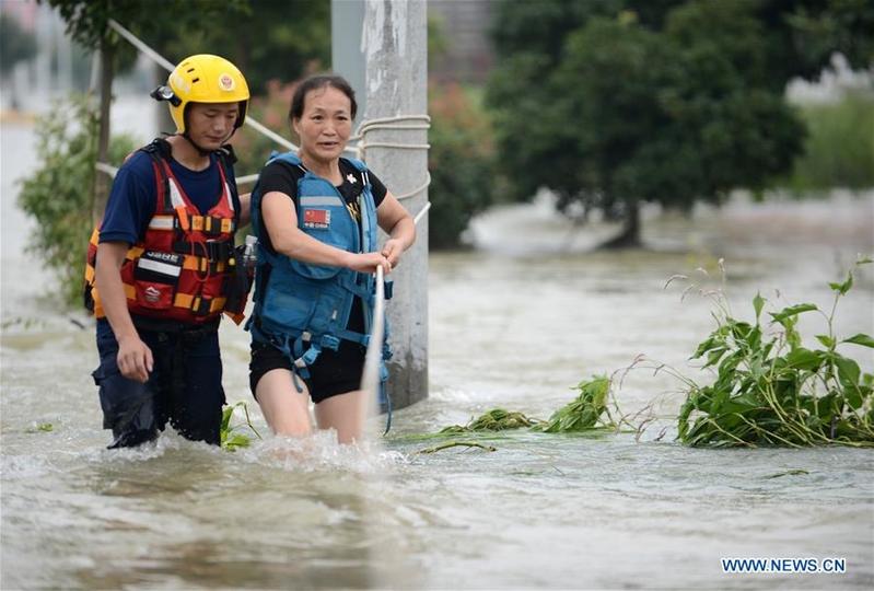 A woman walks in water with the help of a rescuer in Guzhen town of Yu'an district in Lu'an city, East China's Anhui province, July 20, 2020. (PHOTO / XINHUA)
The water level at the Nanjing hydrological station reached a historic high of 10.32 meters as of 2 pm Monday, according to the Jiangsu Water Resources Bureau. The previous record was 10.22 meters in August 1954. The water level will remain high for about a week, according to the bureau.
Nanjing's Qixia district had evacuated 306 elderly or disabled people from Baguazhou Island, the Yangtze's third-largest island, to eight nursing homes by Sunday. Medical workers from 11 hospitals and medical centers accompanied the evacuees to ensure their health during the evacuation and at the homes.
Zhang Guilan, a villager in her 80s, said she was satisfied with the food and living conditions at her nursing home.
"I had a chicken drumstick, cabbage and a bowl of seaweed soup for dinner," Zhang said. "The room I'm living in has a TV, clean bedclothes and bathtub safety rails. The food here is even better than what I had at home."
Zhang said she had witnessed how Nanjing's flood defenses were built and that she had confidence that they would protect the city.
Since 2016, Nanjing has invested more than 8 billion yuan (US$1.14 billion) to reinforce its flood defenses, including the 200-km levee along the Yangtze's main stream.
Contact the writers at houliqiang@chinadaily.com.cn