
 People walk along a sidewalk in New Orleans as the outer eye wall of Hurricane Zeta passed by the city, Oct 28, 2020. (CHRIS GRANGER / THE TIMES-PICAYUNE / THE NEW ORLEANS ADVOCATE VIA AP)
Tropical Storm Zeta is spinning across Alabama after walloping New Orleans, blacking out tens of thousands of homes and businesses and prompting President Donald Trump to declare an emergency for Mississippi.
Zeta is the latest in a grim parade of natural disasters to hit the US in recent months as climate change makes weather increasingly extreme. In California, heat waves, drought and violent winds have combined to fuel a rash of wildfires that have burned a record 1.66 million hectares this year. And along the East and Gulf coasts, a record 11 named storms have hit the US
Zeta made landfall near Cocodrie, Louisiana, with winds of 177 kilometers per hour, before weakening to 96 kph, according to a National Hurricane Center advisory. It’s the fifth hurricane or tropical storm to hit the state this year. There have never been so many major storms hitting Louisiana or the contiguous US in a single season, said Phil Klotzbach, a hurricane researcher with Colorado State University.
Zeta tore through New Orleans at a brisk 50 kilometers an hour, leaving at least one dead in its wake. Damages may still total as much as US$5 billion.
There has been no major flooding and only two to three inches of rain in the city, New Orleans officials said at a press conference late on Wednesday. Several trees and utility poles have snapped, but the main impact right now is the widespread power outages.
“Additional weakening is expected, and Zeta should decay into a non-tropical gale-force low later today,” said NHC’s hurricane specialist John Cangialosi. “The low should become absorbed by a frontal system over the western Atlantic by Friday night.”
Zeta is the latest in a grim parade of natural disasters to hit the US in recent months as climate change makes weather increasingly extreme. In California, heat waves, drought and violent winds have combined to fuel a rash of wildfires that have burned a record 1.66 million hectares this year. And along the East and Gulf coasts, a record 11 named storms have hit the US.
In all, 27 storms have formed across the Atlantic in 2020. So many systems have formed this season that the National Hurricane Center has used up all its official titles and has resorted to the Greek alphabet to designate new ones.
ALSO READ: Hurricane Laura kills 6 in Louisiana, but less damage than forecast
More than 900,000 customers - or about 2.4 million people based on the average size of a US household - across Louisiana, Mississippi and Alabama had lost power as of early Thursday, according to PowerOutage.US, a website that aggregates utility outage data. The electrical failures knocked out traffic lights, and government officials warned residents to stay off the roads.
Zeta becomes only one of six storms to hit the US this late in October and the first hurricane to do so since 1985, said Jeff Masters, a meteorologist with Yale Climate Connection. While Sandy was a powerful storm when it came ashore in New Jersey in 2012, it had lost its hurricane characteristics when it struck land.
Rapid intensification
Zeta grew in strength as it moved across the Gulf, and all through this year six storms have rapidly intensified - short of a record, but indicative of climate change.
“There have been a lot of rapidly intensifying storms and that is something we expect to see in a warming climate,” Masters said.
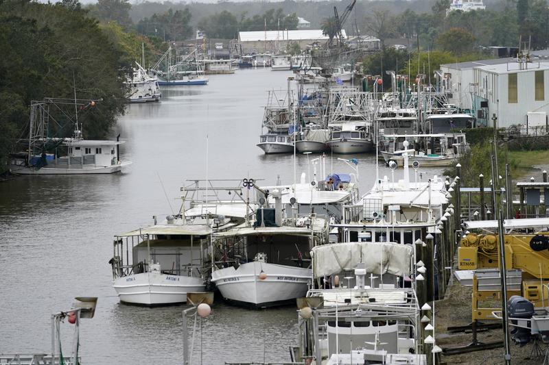 Boats that were moved inland for protection are stacked up in the Violet Canal in Violet, Louisiana, Oct 28, 2020. Hurricane Zeta is expected to make landfall in the afternoon as a category 2 storm. (GERALD HERBERT / AP)
Zeta may cause as much as US$5 billion in damages and losses, said Chuck Watson, a damage modeler at Enki Research, who raised his estimate from an initial US$1 billion as the forecast worsened. The storm’s stronger winds bring more dynamic pressure on everything it hits, and there are simply more targets in the way the closer to New Orleans it gets.
ALSO READ: At least 25 dead as Harvey moves into Louisiana
While the intensity and number of storms has surpassed the 12 that usually form in an average season, there is no indication things will stop as October ends and November begins.
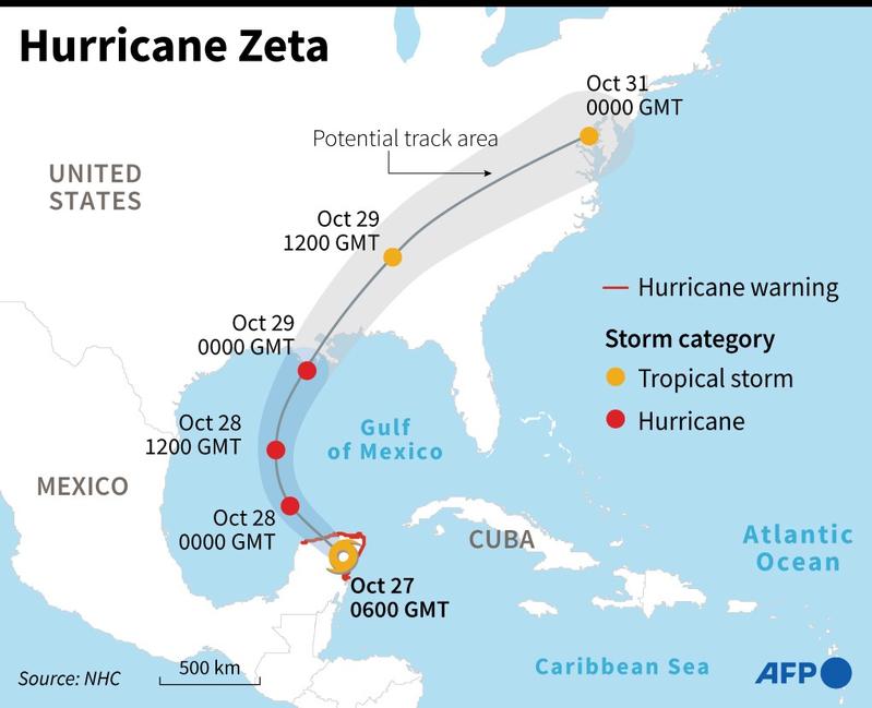 A potential storm could form in the Caribbean Sea within the next week, which would be called Eta. This would be the 28th storm and tie a record with 2005 for the most in a single year.
Not done yet
There might even be more. A global weather pattern called the Madden Julian Oscillation that’s about to exert its influence on the Atlantic may spark a spate of storms. The Atlantic is still warm enough to spin up hurricanes and there are still plenty of tropical waves, the building blocks of hurricanes, emanating from Africa, Masters said.
In addition, autumn cold fronts moving off North America often swirl into tropical storms.
“I suspect we will see one or two of those this year,” Masters said. “Thirty storms are possible.”